ArticlePaid
Get Started
Science

All you need to Know About Tropical Storm Keli

Jul 29, 2025
A detailed overview of Hurricane Iona and Tropical Storm Keli in the central Pacific—tracking their origins, intensities, paths, impacts, and outlook
Lubwa Leonard Lubwa Leonard
10 0 Whatsapp-color Created with Sketch.
All you need to Know About Tropical Storm Keli Articlepaid


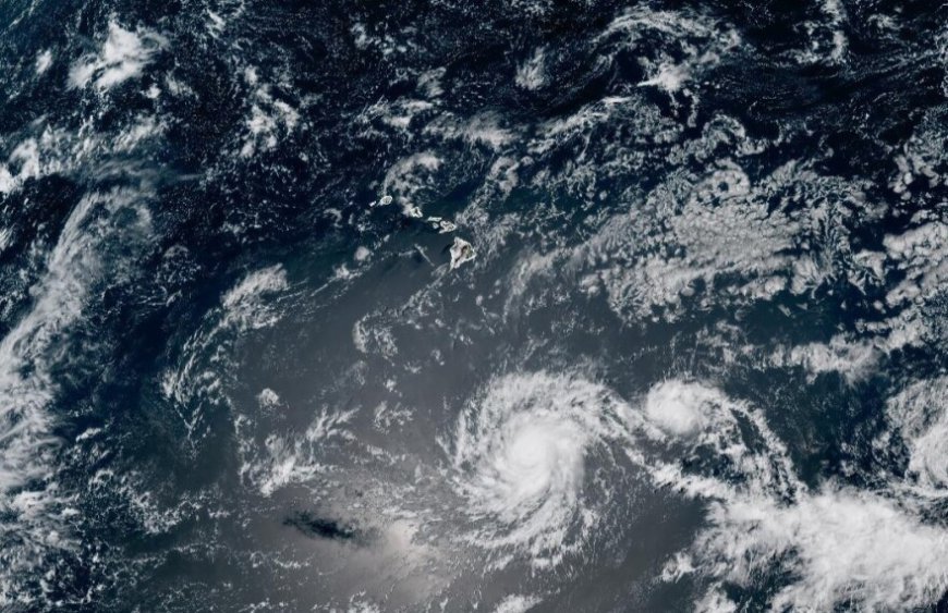
Two simultaneous tropical cyclones—Hurricane Iona and Tropical Storm Keli—are currently active in the central Pacific Ocean, well south of Hawaii. Iona rapidly intensified into a major hurricane, while Keli developed shortly afterward, marking an uncommon occurrence of concurrent storms in the region. Though neither system poses a direct threat to Hawaii, they have prompted close monitoring due to indirect effects such as elevated surf and dry, gusty conditions. This article explores everything you need to know about their formation, structure, behavior, and potential impacts.

Formation and Development of Hurricane Iona

Hurricane Iona originated from a tropical depression that formed over warm open waters, before undergoing extraordinary intensification—jumping from a 50 mph tropical storm to a 115 mph Category 3 hurricane within 24 hours. Such rapid strengthening places it among the top 1% of storms in terms of intensification rates. The storm benefited from unusually favorable ocean and atmospheric conditions, including very warm sea surface temperatures, low wind shear, and high moisture content. This explosive development defied initial forecasts which had predicted it would peak as a minimal tropical storm. Monitoring agencies quickly updated their advisories once microwave satellite imagery revealed the storm’s internal structural improvements, unseen by conventional infrared techniques.
 • Rapid intensification from ~50 mph to ~115 mph in a day
 • Category 3 status achieved—first major hurricane in central Pacific since Dora (2023)
 • Emerged as tropical depression Sunday, named Iona, then tracked westward over open ocean

Formation and Evolution of Tropical Storm Keli

Tropical Storm Keli formed shortly after Iona, designated Tropical Depression Two‑C before strengthening into a named storm. Located roughly 890 to 1,030 miles southeast of Honolulu, it is moving westward at approximately 12–13 mph with sustained winds around 40 mph. Keli is expected to maintain tropical storm strength through midweek before encountering cooler waters and a weakening trend toward a depression. Its relative proximity and follow‑the‑leader path behind Iona are notable—even though both storms remain distant and forecast to remain south of Hawaii. The presence of two named storms at once in the central Pacific is unusual and last seen in 2015.
 • Formation from Tropical Depression Two‑C into Keli on Monday morning
 • Maximum sustained winds ~40 mph, westward movement at 12–13 mph
 • Expected to weaken mid‑week over cooler ocean waters

Current Intensity, Location, and Movement

As of the latest advisory, Hurricane Iona has peak sustained winds around 125 mph, placing it solidly as a Category 3 storm. It lies approximately 765 to 790 miles southeast of Honolulu and continues moving west at about 13 mph. Forecasts predict temporary further strengthening Tuesday before gradual weakening begins Wednesday. Tropical Storm Keli, trailing behind, maintains winds of about 40 mph, situated roughly 890 to 1,030 miles southeast of Hawaii, also moving west. Neither system has triggered watches or warnings, reflecting confidence that they will remain over open ocean and pose no direct threat to land.
 • Iona: ~125 mph winds, ~765–790 miles SSE of Honolulu, westward at ~13 mph
 • Keli: ~40 mph winds, ~890–1,030 miles southeast of Hawaii, following similar westward track
 • No coastal watches or warnings issued for either storm

Historical Context and Regional Rarity

The simultaneous presence of two named storms in the central Pacific is rare—the first dual‑storm event since 2015. Similarly, Iona marks the first central Pacific hurricane in July since Hurricane Darby in 2022. Typically the central Pacific sees only about 3 named storms per season, with around 4–5 total tropical cyclones. The basin’s 2025 season had been forecast by NOAA to be less active (1–4 systems), making the formation of Iona and Keli a surprising uptick. Such rapid formation also underscores the influence of broader climatic conditions—such as El Niño years—on storm frequency and intensity.
 • First dual named‑storm event in central Pacific since 2015
 • First July category hurricane in basin since Darby (2022)
 • Central Pacific averages ~3 named storms per season

Forecast Track and Expected Behavior

Both systems are projected to continue moving west across open ocean, keeping a safe distance from the Hawaiian Islands. Iona is expected to retain its strength into Tuesday, possibly peaking before steadily weakening Wednesday onward as it moves into less favorable conditions. Keli may remain a tropical storm through midweek before diminishing into a depression. Neither storm is expected to turn north or threaten land. The most likely impacts will be elevated ocean swells and subtle atmospheric changes, rather than direct wind or rain.
 • Iona: temporary intensification Tuesday, then weakening over mid‑week
 • Keli: gradual weakening to depression mid‑week as sea surface temps drop
 • Both projected to remain well south of Hawaii

Indirect Effects on Hawaii

Although both storms are distant, indirect effects may be felt—particularly through elevated swells and subtle weather shifts. The National Weather Service anticipates modest increases in wave heights, though not sufficient to prompt marine warnings. Atmospheric subsidence from Iona could produce drier and breezy conditions on the islands, similar to wind behavior observed during Hurricane Dora in 2023, which exacerbated fire risk in Lahaina. However, forecasts emphasize that current impacts are far less intense than during that disaster. A separate, unrelated swell originating east of New Zealand is expected to reach Hawaii around Thursday, possibly causing confusion among residents attributing it to these storms.
 • Elevated surf and minor wave activity possible
 • Dry, breezy conditions due to atmospheric subsidence from Iona
 • Larger unrelated swell arriving from New Zealand later in week

Response and Monitoring by Agencies

The Central Pacific Hurricane Center (CPHC), based in Honolulu and part of NOAA’s National Weather Service, is leading tracking and forecasts for these storms. The Hawaii Emergency Management Agency has convened statewide coordination calls and remains in close communication with all counties. No warnings or watches are active at present, reflecting low threat levels. Officials continue to monitor storm evolution and potential indirect impacts, including surf advisories tied to the unrelated swell pattern. Tracking remains vigilant in case of unexpected shifts in intensity or trajectory.
 • CPHC and NOAA provide official tracking and forecasts
 • Hawaii Emergency Management Agency coordinating county-level monitoring
 • No active watches or warnings; marine observations ongoing

Naming System and Regional Naming Lists

Hurricane Iona and Tropical Storm Keli follow the Central Pacific naming convention maintained by the World Meteorological Organization in coordination with CPHC. These names originate from rotating lists that differ from the Atlantic and Eastern Pacific naming sets. Unlike other basins, the Central Pacific list does not reset each year; instead, names are used sequentially across seasons. Iona is followed by Keli on List 1 of Hawaiian names—a system designed given the lower frequency of storms in this region.
 • Names drawn from rotating Central Pacific lists (e.g. Iona, Keli)
 • Naming does not restart annual alphabetical sequences
 • Lists rotate across seasons due to relatively few storms per year

Why Two Storms Formed So Close Together

The development of two storms in close succession hints at broad favorable conditions in the central Pacific—warm waters, high humidity, and low vertical wind shear. Iona’s explosive intensification likely fostered a conducive environment for Keli’s formation nearby. In rare cases where two systems form within about 800 miles, the Fujiwhara effect can occur—where storms begin interacting and spinning around one another. Reddit observers noted Iona and Two‑C (Keli precursor) were approximately 400 nautical miles apart—potentially close enough for interaction, though current forecasts do not yet show significant interaction.
 • Warm sea surface temperatures, moist atmosphere, low shear supported both storms
 • Proximity (~400 nautical miles) could allow storm interaction via Fujiwhara effect
 • Still early to confirm interaction—models suggest independent westward tracks

Implications for Forecasting and Climate Trends

The simultaneous storm event and Iona’s rapid intensification offer valuable data for meteorologists studying central Pacific storm dynamics and the influence of climate variability. Such events underscore the importance of microwave satellite monitoring, which detected Iona’s structure early when conventional satellite data lagged behind. The surprising activity also calls into question NOAA’s initial long-range seasonal forecasts, highlighting how oceanic and atmospheric anomalies can shift expected trends. As climate patterns evolve, such atypical storm behavior may become more relevant for long-term forecasting strategy.
 • Highlights importance of microwave satellite monitoring in storm detection
 • Challenges assumptions in seasonal hurricane prediction models
 • Provides case study for Central Pacific storm dynamics and rapid intensification

Safety Advice and Public Awareness

Residents and mariners in Hawaii should remain informed, though no immediate threat exists from these storms. Those engaging in ocean or coastal activities should be aware of potential elevated surf and minor swells. Local officials recommend paying attention to high‑surf advisories and not attributing unrelated swells to the storms. Agencies suggest staying updated via official CPHC and National Weather Service forecasts and participating in county‑level briefings should conditions change. Preparedness remains prudent even in absence of direct hazard.
 • Monitor official forecasts from CPHC or NOAA
 • Heed high-surf or advisory notifications—even if not storm‑related
 • Avoid confusing unrelated swells with tropical cyclone impacts

Conclusion


Hurricane Iona and Tropical Storm Keli represent a rare and notable event in the central Pacific—featuring one of the fastest intensifying hurricanes in the basin and a second storm forming in rapid succession. While both remain far from land and pose no direct threat to Hawaii, they are worthy of attention given their unusual characteristics. Iona’s Category 3 strength and Keli’s emergence underscore the dynamic potential of tropical cyclone activity even in typically quieter regions. Indirect effects such as elevated surf and dry, gusty winds warrant monitoring. These systems serve as a compelling case study in climate‑driven storm behavior and early detection techniques, reminding coastal communities of the importance of awareness even when named storms remain distant.

Related Articles
Tsunami Warning in California: Here are the Details
Tsunami Warning in California: Latest Developments
Top 10 Largest Tsunamis Ever Recorded in History
Top 10 Largest Earthquakes Ever Recorded in History
Top 10 Earthquakes That Shook the World and Changed History
What You Should Know About Recent Tsunami Warnings
0 Comments
Login to comment
This website uses cookies for analytics & ads. See our Privacy Policy.

ArticlePaid

Articlepaid is the best site that pays you to write articles online & get paid.
Register now to make money online with Articlepaid.

Install Our App

Download the app to get the best experience and stay updated with the latest content!

Available on Android and iOS devices.

Newsletter

Join our subscribers list to get the latest news, updates and special offers directly in your inbox.

Thanks for subscribing!
Become Freelance Journalist Write and Get Paid ✍️ Terms & Conditions How to Install ArticlePaid App How to Write Article DMCA Policy Writing Guide Privacy Policy Copyright Policy Contact
Copyright © 2024 ArticlePaid - All Rights Reserved.
Link copied!